These pictures were taken within the last two weeks. I have learned to appreciate good photographic subjects in flowers. As usual, human activities are the primary focus of my photo acts.
CHAPTER ONE Physical Characteristics and Demography of Gingoog Geography. The city is located in the northeastern coast of Misamis Oriental, 122 kilometers east of Cagayan de Oro and 74 kilometers west of Butuan City . It is bounded to the east by the municipality of Magsaysay and the province of Agusan del Norte , to the south by Bukidnon; to the west by the municipalities of Claveria and Medina , Misamis Oriental, and to the north by Gingoog Bay . The total land area of Gingoog City is 769.88 square kilometers or 76,988 hectares. The total land area where improvements were built up by people is 1,796.97 hectares agricultural production area is 28,680.51 hectares, while the forest production area is 11,890.00 while the forest protected area is 28,500.65 hectares. Climate Gingoog has a Type 2 climate, which means that it has no distinct dry season. Rainfall occurs during the months of September to February. The average temperature is 27 degrees to 32 degrees on t...
EARLY DAYS Eureka was just one of the sitios of Barangay Malibud when it was still part of the logging concession of the defunct Anakan Lumber Company (ALCO). The inhabitants of this place were natives called Higaonons. Higaonons were one of the loosely grouped tribes in Northern Mindanao extending as far as Iligan in the West and Agusan Del Sur in the East. Higaonons trace their ancestry to Datu Pabuloson their legendary progenitor from Patag, Tagoloan, the original enclave of the Higaonon tribe. From Patag in Tagoloan the Higaonon people made their trek to the mountains of Misamis Oriental. According to Apo Mandilguhan Ansihagan a Datu of Baliguihan, they were guide by a crow who they thought was the spirit of their ancestor. Whenever the crow alighted and rested on a tree branch, the Higaonons would camp out for several days. Then the bird would hover around their camps, signaling that they should break camp and continue with their sojourn. When they r...
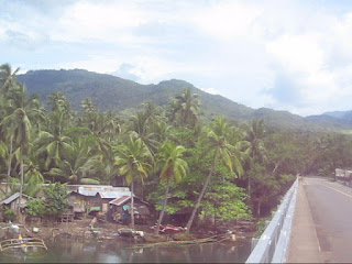
Odiongan is an old settlement datring porobably to the 15th century. THe Recollect missionaries were here in the 17th century but left no major buildings as proof. They just established a chapel and left after a few years, may be due to the hostility of the natives. Old Spanish maps indicate it as Oyungan. Odiongan is named after the large sea shell called locally as bodyong. The shell is made into a bodyong or improvised horn to call members of the tribe for a meeting with the Datu. The Datu is a tribal leader who oversees the affairs of the tribe. Datu Odyong was one such legendary figure after which Odiongan was named after. Odiongan River is also the largest river in Gingoog City. It may also be the longest. Its source is at Mt. Lumot, near Mt. Balatukan. The mouth of Odiongan River was once a thriving community of fishermen, Boholano and Chines traders. In the olden times ceremonies were conducted by Baylan to appease the spirit of the river, which claims lives every year. Food an...


Comments